
LandSFACTS v.2 (previous)
“For the latest development of the tool, please refer to here instead.”
LandSFACTS v.2 (LANDscape Scale Functional Allocation of Crops Temporally and Spatially) is a modelling tool to create scenarios of crops or land uses within the landscape. The model provides a crop/ land use per land unit per year, which meets user-specified spatial and temporal constraints on the crops/land uses. The software is spatio-temporal and allows multi-scaling. The modelling is based on stochastic and rule-based processes complemented with simulated annealing. The model has been used to create scenarios of cropping systems and land uses from the farm level up to the regional scale in order to assess ecosystem services, such as biodiversity, water quality, soil erosion, carbon sequestration.
A standalone interface is available to facilitate user interactions for this version of the model (cf. screenshot).
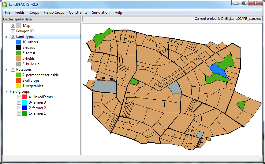
LandSFACTS interface v2.0.4 screenshot
Model details
The LandsFACTS model was originally (v1.6) set up to simulate cropping systems at the landscape scale. Since 2007, it was further developed to allow modelling land uses at multiple scales within an evolving environment. The diagram below presents the main inputs and outputs of the model v.2.
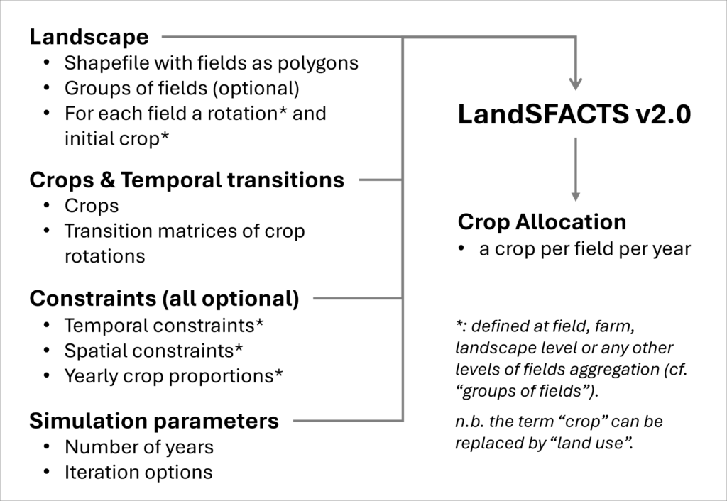
LandSFACTS version 2.0 inputs and outputs
Temporal constraints: return period, minimum and maximum repetition of crops within a field, forbidden crop sequences, past allocations. Each constraint can be field specific.
Spatial constraints: yearly land capability, separation distances between crops, linked fields. In progress: connectivity metrics.
Downloads
“For the latest development of the tool, please refer to here instead.”
The LandSFACTS software v2.0.4 is available in several formats:
- with graphical interface, helpfile and tutorial [XP, W7], cf. below
- command-line [XP, W7, W7 x64, Linux x64], by request
- dynamic libraries [XP, W7, W7 x64, Linux x64], by request.
The command line version allows work with larger landscapes (for example, 2 millions polygons) but requires more pre-processing of the data and a more in-depth knowledge of the model. Linux x64 was tested on SL6.1.
The software development is an ongoing process and you can email Marie Castellazzi to get the latest version or to report any bugs or any feature requests.
Software downloads with graphical interface and tutorial :
Software and Help file [XP, W7 compatible]: LandSFACTSv2-0-4.zip
Unzip the file, on a local drive, and double-click LandSFACTS.exe to launch the software. Use the tutorial below for an introduction to using the software, and browse the help file for detailed information.
Examples and tutorial with data: LandSFACTSv2-0-4_Tutorial.zip
Help file only: LandSFACTS.zip
The help file is in .chm format, and to open correctly, it needs to be saved on a local drive (for example, C, D).
Licence
The software is released under GNU public licence, and is therefore free to use and develop. The code sources are available upon request.
This program is distributed in the hope that it will be useful, but without any warranty; without even the implied warranty of merchantability or fitness for a particular purpose. See the GNU General Public Licence for more details.
Acknowledgement and Funding
version 2.0:
The software was developed within Programme3, at the Macaulay Land Use Research Institute (Marie Castellazzi, Iain Brown). Its development is also supported by Biodivagrim ANR at INRA SAD-Paysage (Alexandre Joannon). Julien Keruzec, student funded by Biodivagrim, redeveloped the software interface.
Until version 1.6:
The software was initiated within the SIGMEA EU project, and was developed from 2004-2007 at Rothamsted Research by Marie Castellazzi, Joe Perry, Kelvin Conrad, and Joanne Matthews.