
Land Systems Research Team
The Land Systems Team are a group of researchers within the Information and Computational Sciences group of the James Hutton Institute. Historically the team were involved in the development of farm-scale land use decision support systems (LADSS). Since 2006 the focus and expertise of the team has moved increasingly towards supporting national-scale policy making in a range of land related domains. For publications related to each area of work, or external pages related to projects, see below.
Land-related datasets used and created by the Land Systems Research Team
Click on any of the nodes to the right to find out more information
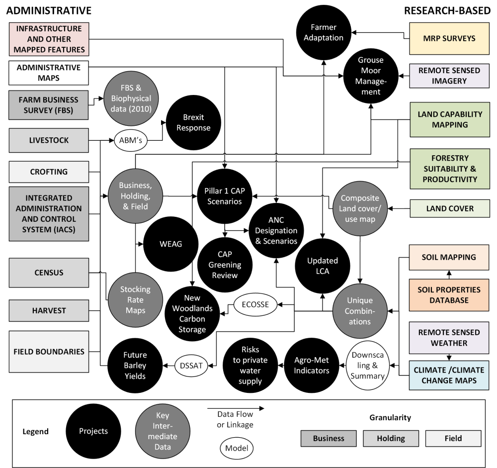
Infrastructure and Other Mapped Features
OS MasterMap includes data like roads, buildings, parks, fields, fences, paths and more.
Administrative Maps
- Agricultural Parishes
- Agricultural Regions
- Designations & Frameworks
- Socioeconomic Disadvantage
- Urban-Rural Classification
Farm Business Survey (FBS)
- Farm Business Survey
- Land Management
- Business Viability (annual dataset since 2000)
Livestock
- Movement of livestock and horses
- Breed, Number, Location
- APHA (CTS, ScotEID)
Crofting
- Common Grazing
- Shares & Apportionments (annual dataset since 2000)
Integrated Administrative and Control System (IACS)
- Payments, Land Use, Ownership, Seasonal Rentals (annual dataset since 2000)
The following page contains information about the data collected in context:
https://www.ruralpayments.org/topics/apply-for-funding/single-application-form/
Census
Tenure, Land Use, Livestock Numbers and Types, Machinery, On-farm diversification
- June Ag Census
- December Ag Survey (annual dataset since 2000)
- Standard Outputs (annual dataset since 2011)
- Farm Types (annual dataset since 2011)
- Farm Structure Survey (conducted 3 to 5 times since 2000)
Harvest
- Harvest Summary
- Crop Yield (annual dataset since 2010)
Field Boundaries
- Land Parcel Identification System (continuous dataset since 2000)
MRP Surveys
- Attitudes, Activities and Plans
- CAP Intentions Survey (2013, 2018)
- Rural Business Survey (2018, 2019)
Remote Sensed Imagery
- GetMapping (25cm grid)
- Planet Scope (5m grid)
Land Capability Mapping
- Agriculture & Forestry
1:50,000 (lowlands)
1:250,000 (uplands)
Forestry Suitability & Productivity
- Ecological Site Characterisation
- Forest Yield
- Woodland Carbon Code
Land Cover
- National Forest Inventory (annual/decadal dataset starting from the 2000s)
- Land Cover Map GB (2000, 2007)
- Land Cover Scotland (1988)
Soil Mapping
- Natural Resource datasets
1:25,000 (series, lowlands)
1:250,000 (map units, Scotland)
Soil Properties Database
- Series
- Profiles
Remote Sensed Weather
- SolarGIS Solar Radiation
(1994-2017, ~2.2km grid)
Climate/Climate Change Maps
- Observed: 1960-2018, 1km grid
- UKCP09: 1960-2099, 5km grid
- UKCP18: 1981-2080, 1km grid
- MIDAS Point location weather
Farmer Adaptation
Based on large survey of land managers a series of analyses of new entrants, diversification, non-commercial farming [1] and female-led farms have been undertaken. The surveys were structured by the Census and IACS data.
- Sutherland, L.-A., Finding ‘Hobby’ Farmers: A ‘Parish Study’ Methodology for Qualitative Research. Sociologia Ruralis, 2020. 60(1): p. 129-150.
Grouse Moor Management
As part of a wider analysis of grouse moor management, this project identified and characterised holdings with grouse moors. The analysis assessed the potential for alternative uses, updated the mapping of strip-burning using remote sensed data and refined the estimates of grouse butt density as an indicator of intensity of management.
Brexit Response
Used agent-based modelling to assess how cattle-based systems in Scotland might respond to Brexit [1]. The models were parametrised with data from APHA (see Census) and SG Census/IACS.
- Ge, J., et al., Not one Brexit: How local context and social processes influence policy analysis. PLOS ONE, 2018. 13(12): p. e0208451.
Read more about it here.
Pillar I CAP Scenarios
Undertook a series of options analyses for transition from historic to area-based payments [1]. Emphasis was on how to regionalise payments (land use, capability etc.) and the degree of redistribution between regions and sectors. Used in the Pack Inquiry and for CAP Stakeholders Group briefings.
- Matthews, K.B., et al., Reforming the CAP With area-based payments, who wins and who loses? Land Use Policy, 2013. 31: p. 209-222.
Read more about it here.
Read about our work on CAP more broadly here.
ANC Designation & Scenarios
Areas Facing Natural Constraint (ANC) was the planned replacement for the Less-Favoured Areas (LFA). This project undertook the testing of options for designations (biophysical) and how payments would be distributed. This formed the basis for a 2016 ANC workshop, and further analysis in 2019/20.
Read more about it here.
Woodland Expansion Advisory Group
The Woodlands Expansion Advisory Group (WEAG) informed land use strategy in the Scottish Government. Analysis was undertaken to identify and assess the quality (LCA classes) of unstocked and lightly stocked land across Scotland.
Read more about it here.
CAP Greening Review
This study assessed trends in environmental indicators, the uptake of CAP Greening measures in 2014, with maps and provided an expert review of their likely effectiveness.
Read more about it here.
Updated LCA
This project uses the improved resolution climate data and enhanced soil properties datasets to update the Land Capability for Agriculture (LCA) mapping with emphasis on looking forward to changes by 2050 [1].
- Brown, I., et al., Climate change, drought risk and land capability for agriculture: implications for land use in Scotland. Regional Environmental Change, 2011. 11(3): p. 503-518.
New Woodlands Carbon Storage
This project mapped the net carbon storage for 11 forestry management alternatives for new woodlands on all non-forested land in Scotland [1]. This use the unique combinations dataset with the ECOSSE soil carbon model and datasets from Forest Research.
- Matthews, K.B., et al., Not seeing the carbon for the trees? Why area-based targets for establishing new woodlands can limit or underplay their climate change mitigation benefits. Land Use Policy, 2020. 97.
Future Barley Yields
This used the unique combinations datasets with the DSSAT crop model to model current and future barley yields under climate change. The analysis was validated against holding-level harvest yield data and informed deliberation with Scotch Whisky Research Institute.
Risks to Private Water Supply
This used the spatial climate data to highlight where changes in rainfall under climate change may cause supply interruptions. Change in evapotranspiration and land use may also have an impact.
Agro-Met Indicators
This project downscales the regional climate model data [1] and generates summaries of risks from climate change using agro-meteorological indicators developed in previous analysis [2]. Website forthcoming.
- Rivington, M., et al., Downscaling regional climate model estimates of daily precipitation, temperature and solar radiation data for specific locations. Climate Research, 2008. 35: p. 181-202.
- McCrum, G., et al., Adapting to climate change in land management: the role of deliberative workshops in enhancing social learning. Environmental Policy and Governance, 2009. 19: p. 413-426.
FBS & Biophysical Data (2010)
This 2010 dataset generated biophysical descriptions of the Farm Business Survey sample, linked via [1] and used to estimate the physical limits of performance for businesses in the LFA. This linkage is in 2020 part of ongoing research.
- Matthews, K.B., et al., Reforming the CAP With area-based payments, who wins and who loses? Land Use Policy, 2013. 31: p. 209-222.
Business, Holding & Field
This dataset links the three administrative levels of agriculture with unique identifiers, and makes it possible to map data such as land use, payments, tenure etc and visualise GIS analysis to link in the research-based map datasets. It is used for nearly all projects.
Composite Land Cover/Use Map
A map based on (in priority order) OS data (inland water, urban, infrastructure), National Forest Inventory, IACS per field land use and Land Cover Map 2007.
Stocking Rate Maps
Maps of livestock units per hectare generated per holding from Census livestock numbers and grazing land covers. Informed Commons Agricultural Policy (CAP) options, and inputs to Woodland Expansion Advisory Group (WEAG) deliberations.
Read more about it here.
Unique Combinations
The unique combination of climate, soils and land use across Scotland.
Used as inputs to crop and woodlands modelling, designation of options for the ANC boundary and an LCA update.
ABM's
An agent-based model (ABM) is a class of computational models for simulating the actions and interactions of autonomous agents (both individual or collective entities such as organizations or groups) with a view to assessing their effects on the system as a whole.
ECOSSE
"The ECOSSE (Estimation of Carbon in Organic Soils – Sequestration and Emissions) model simulates soil carbon and nitrogen dynamics in both mineral and organic soils using meteorological, land use, land management and soil data, and simulates changes in soil organic carbon and soil greenhouse-gas emissions."
Read more about it here.
DSSAT
"The Decision Support System for Agrotechnology Transfer (DSSAT) is a software application program that comprises crop simulation models for over 42 crops (as of Version 4.7.5) as well as tools to facilitate effective use of the models."
Read more about it here.
Downscaling & Summary
Rivington, M., et al., Downscaling regional climate model estimates of daily precipitation, temperature and solar radiation data for specific locations. Climate Research, 2008. 35: p. 181-202.
Major Areas of Work:
- Supporting Scottish Government’s CAP reforms. See: Supporting CAP reform in Scotland page.
- Analysis of Woodland Expansion and its effects on Carbon Stocks. See here for press release.
- Climate Change via agrometerological indicators.
Current Projects:
- Land Use Transformations (RESAS C3)
- Scotlands Land Reform Futures (RESAS E3)
- MERLIN
- MOVING
- Societal Metabolism